Feb. 26, 2013
George Washington called Charlotte a “trifling place.” Even if to many people it remains a trifling place, it certainly is a bigger trifling place.
The city has taken full advantage over the years of North Carolina annexation laws. Cities are the subservient creatures of the state. But the theory behind the N.C. statute over the years has been that places in North Carolina that are urban in nature should be municipal in governance.
How to quantify the definition of “urban?” North Carolina has traditionally depended primarily on a count of the number of residents per given quantity of real estate. But to that base there have been some additional standards. This is not the place for getting into those weeds.
The motive was in part financial: Urban areas would demand additional services, so give the nearby city the power to tax and the responsibility to provide those services.
The effect has been to allow Charlotte to absorb the subdivisions and other development built at the city’s edge, to have the resources to provide the services urban residents required, and through zoning to have a say in how developers used the land that would one day be inside the cit.y
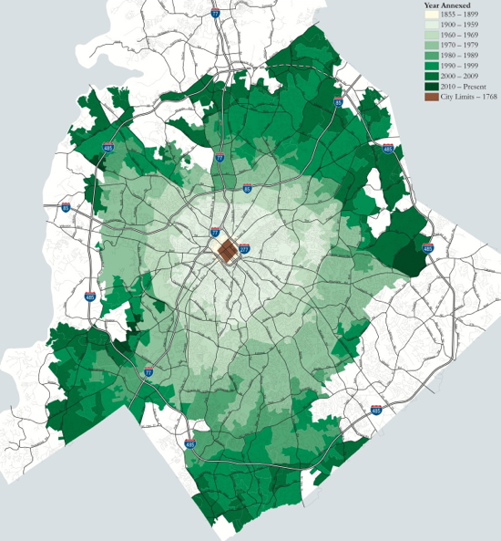
In the Charlotte map above, the speck in brown marks the size of the city in George Washington’s day. The subsequent annexations are in ever-deeper shades of green. In JFK’s day, I-85, Park Road Shopping Center and Eastland Mall were all outside of Charlotte. SouthPark was a cow pasture.
The development community during the 20th century had a large, some would say oversized, say in the city’s development. Whatever the truth in that regard, it is undeniable that city policy until the very end of the 20th century favored low-density, auto-dependent suburban development.
Compared to a city like Greensboro, Charlotte was late to the party in development a road system that would serve multiple employment centers. Until the 1970s, essentially all traffic arteries were spokes of a wheel emanating from George Washington’s Charlotte. Even in 2013, the bus system mirrors that dominance of spokes, forcing most long-distance bus riders to go downtown to transfer.
Source: Download Planning Department’s annexation map in PDF
